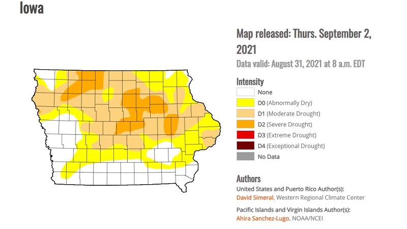
U.S. Drought Monitor's latest map for Iowa show drought conditions improving. | droughtmonitor.unl.edu/
U.S. Drought Monitor's latest map for Iowa show drought conditions improving. | droughtmonitor.unl.edu/
Iowa went into this past Labor Day weekend with some excellent drought news.
Recent rains in Iowa have dramatically improved drought conditions in the state, according to the latest map issued by the U.S. Drought Monitor.
The Iowa Flood Center was quick to spread the good news.
"A quick look at how Iowa's drought conditions have changed this week (left) compared to last week (right) in response to the recent rainfall," the center said in a Friday, Sept. 3, Twitter post that included the most recent drought monitor maps.
The map for Iowa issued Thursday, Sept. 2, shows that no portions of the state are experiencing extreme drought. That marked a change from the week prior, when more than 10% of the state was in extreme drought, KCCI reported.
Only 12% of Iowa was in severe drought, mostly in northern and north-central Iowa, according to KCCI, a drop from 33% since early June.
Almost 60% of Iowa was in the "severe drought" category the last week of August but by Sept. 2, 13% of the state was in that category, KCCI reported. In addition, about 45% of the state was in "moderate drought" and 72% reported abnormally dry conditions.
The U.S. Drought Monitor is a joint project of the University of Nebraska-Lincoln's National Drought Mitigation Center, National Oceanic and Atmospheric Administration NOAA and the U.S. Department of Agriculture, according to its website.
The latest map showed "widespread one-category improvements" in Iowa, Minnesota, and Wisconsin the U.S. Drought Monitor noted in an Aug. 31 summary. The improvements were the result of "beneficial rainfall accumulations observed" that week with rainfall totaling 2 to 12 or more inches.
"The heaviest accumulations were observed across areas of northeast Iowa, where the 7-day average streamflow on the Cedar River at Janesville, Iowa was in the 99th percentile, according to the USGS," the summary said. "Elsewhere in the region, modest rainfall during the past week (1 to 2 inches) led to reductions in areas of Abnormally Dry (D0) in Illinois, Indiana, Kentucky, and Ohio."
Average temperatures that week were well above normal across Iowa and most of the U.S. Midwest, according to the summary, which cited information from NOAA.


 Alerts Sign-up